New Zealand: The Routeburn Track & the Tongariro Northern Circuit
- Matt Carter
- Mar 3, 2019
- 8 min read

New Zealand may be a country far far away from New York City, but it is so worth the 18 hours of flying it takes to get there. Made up of two main islands (the North and South Islands), the country has countless opportunities to enjoy the outdoors. You can hike, bike, climb, ski, swim, raft, bungy, sky dive or try and count its millions of sheep -- no matter what you'll be sure to have the best time. In February, I visited the country for three weeks with my fiancé, whose family lives there. We hiked up, down and around both islands, and within hours of arriving back home were already planning which climbs, hikes and other adventures we'd do on our return.

While New Zealand has a hiking trail just around every corner, I recommend trying to do at least one of their ten "Great Walks," each of which takes at least a few days and are a great way to see the country's flora, fauna and magnificent landscapes.
New Zealand's Ten "Great Walks":
Abel Tasman Coast Track (3 - 5 days)
Heaphy Track (4 - 6 days)
Kepler Track (3 - 4 days)
Lake Waikaremoana (3 - 4 days)
Milford Track (4 days)
Paparoa Track and Pike 29 Memorial Track (opening 2019)
Rakiura Track (3 days)
Routeburn Track (2 - 4 days)
Tongariro Northern Circuit (3 - 4 days)
Whanganui Journey (3 - 5 days)
This blog focuses on two of these great walks -- the Routeburn Track and the Tongariro Northern Circuit. It's essential to plan far ahead for each of these walks as bookings for their huts and campsites, which are released months in advance, sell out fast (we had also planned to do the Milford Track to see the fjords, but all the huts were booked within just a few hours of being released!).
The Routeburn Track (2 - 4 days - 32 kilometers)
The Routeburn Track is a 32 kilometer / 20 mile track that takes you through two of NZ's national parks, Aspiring and Fiordland, in the southern alps.
To get to the track, you'll either need a car or to book a shuttle from town. The towns closest to the trail are Queenstown and Te Anau, both of which have shuttle services that can drop you off and pick you up at a set time from either trailhead. The shuttle services' return trips cost about $80 (USD) pp.
While some people chose to run this track in a day, hikers should plan to complete it in 2 - 4 days. We hiked it in 3 but could have done it in 2, as we arrived at each of our huts by 3PM with enough energy to keep going. The longer options of 3 or 4 days are great for folks who don't usually hike or who like to take their time. Three days ended up being ideal for us, as the huts were in beautiful locations, and spending afternoons exploring surrounding trails made for some of the best memories. I'd look at the distance(s) and elevation gain between huts when deciding how long you want to complete the hike, and then book your accommodation accordingly.
Hikers can start from either direction; we chose to go from the Routeburn Shelter towards the Divide*:
Day 1: Routeburn Shelter to the Routeburn Falls Hut (8.8 km / 5.5 miles)
Day 2: Routeburn Falls Hut to Lake Mackenzie Hut (11.3 km / 7 miles)
Day 3: Lake Mackenzie Hut to The Divide (12 km / 7.5 miles)
*We chose to skip the Routeburn Flats Hut and Lake Howden Hut as the distance between points was very short, but they are a good back up if the other huts are fully booked.

The huts along this hike were some of the best I've stayed in, complete with flush toilets and gas stoves, each perched in a beautiful location. If you plan to travel with a tent, there are also campsites available at a lower cost alongside each hut. International visitors pay $130 a night for a hut and $40 for a campsite. If you happen to be a kiwi or NZ permanent resident, the rates are significantly reduced. Or if you go in the off-season (May 1 - October 22), there are no fees and huts and campsites are first come, first serve. Just remember to bring earplugs as even the nicest huts are still filled with heavy snorers.

Each day of this trek was different, with terrain and landscapes seemingly changing every couple of hours. The track itself, which is lined by ferns and moss, is well maintained and extremely easy to follow. The park rangers have recently taken significant measures to trap stoats and possums that were previously decimating the park's native bird population, and you can both see and hear the impact of this work -- the hike has its own bird orchestra with kea, tui, rifleman and more singing to you along the way. And while there is a bit of trail on either side of the route that day hikers attempt, for the majority of the trek it's just you and the birds.


Some of the highlights along the trail include Harris Saddle, Lake Mackenzie, Key Summit and Earland Falls, all of which are great places to stop and reflect on how peaceful and wondrous a hike this is.


For more information on the Routeburn Track visit New Zealand's DOC website.
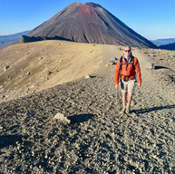
The Tongariro Northern Circuit (3 - 4 days, 43 kilometers)
The Tongariro Northern Circuit is a 43 kilometer / 27 mile loop, and a longer version of the Tongariro Alpine Crossing, which is one of the world's most popular day hikes with up to 5,000 visitors a day. It's part of the Tongariro National Park which was NZ's first national park, established in 1894, and an active volcanic zone.
To get to the track you'll either need a car or to book a shuttle from town. The towns closest to the trail are Taupo, Turangi and Whakapapa Village, all of which have shuttle services that can drop you off and pick you up at a set time from either trailhead. We took the shuttle service from Taupo, the largest of the three towns but also the furthest away (an hour and a half drive) and a return trip cost about $100 (USD) pp (prices vary depending on if you have a private or group shuttle and from which point you're starting).
NZ's Department of Conservation (DOC) advises that the track can be done in 3 - 4 days, but some people do it in 2 (staying at the Oturere Hut and hiking about 12 hours each day, or choosing to start at Mangatepopo's car park and cutting out 8.5km of the trek). We hiked it in three days and felt that was well suited - any shorter would have been too tough to be truly enjoyable and any longer would have meant we'd have hiked an average of only three hours each day.
Hikers can start from either direction, we chose to go from Whakapapa Village towards the Mangatepopo Hut rather than the Waihonhono Hut (the opposite way has hikers in more exposed terrain and hiking in steep elevation during the latter part of the day, whereas this route allowed us to get the hardest parts over with in the early morning before the sun was at its strongest ):
Day 1: Whakapapa Village to the Mangatepopo Hut (8.5 km / 5.3 miles)
Day 2: Mangatepopo Hut to Waihohonu Hut (20.3 km / 12.6 miles)
Day 3: Waihohonu Hut to Whakapapa Village (14.3 km / 8.9 miles)

The huts on this hike were in beautiful locations, each with campsites alongside them. They were outfitted with gas stoves, but less modern and more limited than the Routeburn Track (they did not have flush toilets) and with the exception of the Waihohono Hut, had small common areas -- the Oturere Hut even had bunk beds in the kitchen. It's $36 pp to book a hut or $15 pp for a campsite. And if you go in the off-season (May 1 - October 22), there are no fees and huts and campsites are first come, first serve. Like all the huts on the great walks during off-season, the huts are not staffed with rangers and there's no gas.
The looped trail takes you past dormant volcanoes, diverse ecosystems and amazing vistas. Each day of you'll see different terrain from the day before, some of which has you feeling as if you're on Mars.

The first day of the trek was our shortest, with dusty, eroded and unmaintained trails, which were more than made up for with amazing flora and views of Mount Tongariro, Mount Ruapehu, Mount Ngauruhoe and Mount Taranaki. We arrived at Mangatepopo Hut with plenty of time to wander around some nearby trails and take in a beautiful sunset.
On the second day, we started out before sunrise (6AM) to beat the crowds headed for the Tongariro Alpine Crossing. This meant we were able to enjoy the beautiful Emerald lakes with only a few other hikers and avoid what would soon become a parade of people. The looped trail gives you almost constant views and different perspectives of the stunning Mount Ngauruhoe (aka Mount Doom from Lord of the Rings), which last erupted in 1977. And quite a few hikers veer off trail and attempt to hike it as part of their trek, but the local Maori have asked people to stop doing this as the mountain is sacred to them and find it disrespectful to summit. It's also important to note that visitors should not eat next to nor bathe in the lakes along this trail, as these too are sacred to the local Maori.
You won't hear as many birds on this trail as you can on other NZ hikes, due to the Mars-like conditions, but if you're lucky, there are apparently kiwi and morepork that have sing-alongs near the Waihohono Hut.


A necessary warning about this trail is that much of it is exposed to the elements, whether it be the hot sun or gail force winds, so it is incredibly important to pack enough water, sunblock and layered clothing to protect you. When we did the hike this past February, the area was experiencing drought-like conditions, with limited opportunity to refill water bottles. Even the water at each of the huts was being pumped in from streams, which we had to boil or treat, so we always carried 4 litres on us just to be safe, refilling from hut to hut. There are also a lot of warnings against hikers attempting this trail in the off-season as weather can make it a treacherous journey, which has sadly seen a few hikers pass away on the trail this past year. Be sure to always check the weather forecast before heading out, and only attempt this hike if all is clear or you are fully confident that you're prepared for the conditions ahead.
On the third and final day of the trek, we set off from Waihohonu Hut, which is next to one of the oldest huts in New Zealand, and that you can go inside and see how people used to camp in the early 1900s. The men had some nice bunk beds, a few amenities and a fireplace to keep them warm, while the women were delegated to a tiny sparse room by themselves. Luckily things have since changed and everyone who stays in the modern-day huts should be comfortable enough for the hike they have ahead of them.


Near the end of the trail we came to Taranaki Falls, which are a beautiful and great way to end your trek. There are two access points to the falls, but the one between Waihohono and Whakapapa is more idelic than the one between Mangatepopo and Whakapapa. Once there, you can hop in below the falls for a swim or hang out up top on the ledge and eat the last of your snacks.

For more information on the Tongariro Northern Circuit visit New Zealand's DOC website.
Remember to pack plenty of water, food and treats to help keep you going on these hikes. A list of what we packed is below:
Camelpack (2 liter)
Platypus (1 liter x 2)
Ready to eat meals
Peanut butter and jelly sandwiches (GF Vogel bread for the win!)
Trail mix (with chocolate)
Chocolate granola bars
Chocolate
Hot chocolate
Miso soup mix
Coffee
Tea
Edam cheese (it's Made backwards)
Sleeping bag liners (to cut down on weight we just brought liners and were warm enough)
Burt's Bees wet wipes (there are no showers)
Contact me if you have any questions about planning your trek to New Zealand!


Comments